the Columbia River Historic Highway and drive through Corbett, past Crown Point down the hill and past Latourell Fall and Bridal Veil Falls. You may want to stop at Bridal Veil Falls for the excellent bathroom (as well as the short hike to the falls). The next trailhead parking is for the Angel's Rest trail and there is no bathroom of any kind.
The Angel's Rest trail goes up almost from the start and soon you cross a talus slope (basalt, of course). I usually hear the calls of pikas here, but I rarely see them. It sounds like "eeeep!" Ochotona princeps is a small rodent (related to rabbits but in its own family) that lives in rocky areas of Western North America usually at much higher elevations than here. They eat green plants and store stockpiles of dried plants in rock crevices.
 |
| Stonecrop is blooming on another talus slope |
A glimpse of lower Coopey Falls from the trail.
The trail crosses Coopey Creek, this is the only water available on the trail (Arrow is not thirsty yet). You will want to keep your dog on a leash on this trail - steep slopes all the way up and hazardous cliffs at the top.
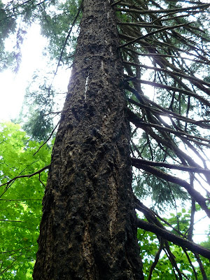
There was a fire in the area in 1991 which burned part of the upper trail and surrounding area (over 800 acres in size) and threatened nearby Multnomah Falls lodge. This Douglas fir was scorched but the thick bark protected the tree and it survived the fire. Traffic was stopped on I-84 as helicopters flew big buckets of water scooped up from the Columbia River to drop on the burning forest near the lodge (my parents happened to be on the highway at the time and witnessed this).
More of the burned area which has regenerated with lots of Red Alders and understory shrubs. The dead, standing snags are providing food and nesting habitat for insect-eating birds such as woodpeckers.
 |
| Closer to the top, a view of the Columbia River and the burned area |
At the top, (2.3 miles from the trailhead) there are piles of rock and shrubby areas. Arrow and Mr. Thornsby look toward Washington and I-84 below.
Mr. Thornsby looks at snags left from the fire closer to Multnomah Falls. (which we shall be visiting soon)
On the way down, a peek at
Coopey Falls just off the trail.


